Seabirds track ocean winds
Tracking the flight of birds is found to be a good way to map winds on the surface of the sea, says S.Ananthanarayanan.
The weather cock and the “single swallow that does not a summer make” represent the role that our feathered friends have traditionally played in climate science. It should not, hence, come as a surprise that following birds which fly above the sea turns
out to be more accurate than satellites or anemometers to get a picture of low altitude winds over the oceans.
Yoshinari Yonehara,, Yusuke Goto, Ken Yoda, Yutaka Watanuki, Lindsay C. Young, Henri Weimerskirch,
Charles-André Bost, and Katsufumi Sato, from the Tokyo University, Universities of Nagoya and Hokkaido in Japan, in Honolulu and the Unversité de La Rochelle, in France, report in the Proceedings of the National Academy of Sciences (PNAS) that flight paths
of soaring seabirds can complement existing sea surface wind data by providing very fine grained and rapid information of wind velocities.
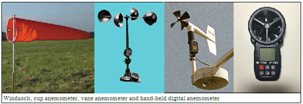
The traditional devices are the windsock, which was once a familiar sight at airports, which were called aerodromes, and then the more sophisticated anemometers. While the windsock only showed the direction of the wind, there were other devices to measure
its speed. The first was the cup anemometer, which was set spinning by the wind. The next was the vane anemometer, which was little windmill with a tail. The speed of the spin was converted to wind speed by a counter, or even a dial. And there is the hot wire
anemometer, where how much a hot wire cools in the wind is measured by the change in the electrical resistance of the wire.
The weatherman also tracked the changes in wind speed and direction by sending up a hydrogen or helium balloon with a metal plate hanging from it. The plate served to show up in a radar screen and indicate the wind speed and direction at different altitudes,
as it rose up and up. Much more sophisticated is the laser Doppler anemometer, which depends on the change in frequency of laser light that is reflected by very small particles in the air. This is the method used to survey the wind distribution around a real,
power generation wind turbine.
The PNAS authors explain that these are really methods only to sample the wind speed at a few locations that are far apart and the sampling is often not continuous. For recording the wind behaviour on the surface of the sea, which is important to understand
the climate and also in coastal areas, the only means available was anemometers mounted on buoys that were distributed over a limited area being monitored.
The modern method, which is used to study winds over the surface of the sea, is with the help of satellites and a device called a scatterometer. In this method, pulses of microwaves, which are very short wavelength radio waves, are sent down to the earth
from a satellite, and the reflected pulses are detected. Winds create ripples on the surface of water, which can grow into large waves or swell, in the open ocean. While ripples are waves on the surface only, depending on the tendency of the surface not to
be pierced by the wind, the weight of the water being displaced also comes into play, and the resulting waves are in equilibrium with the wind. The pattern of such waves on the water leads to alternately lower or higher points of reflection and this leads
to mutual interference of the reflected radio waves, which can be related to the speed and direction of the wind. As the satellite goes round, it scans the entire earth and in conjunction with data from buoys stationed all over, which helps weather forecasts
and the study of ocean dynamics.
But the PNAS authors point out that a satellite observes each area only twice a day and the buoys are also far apart. The picture created is thus not fine grained and details of changes in winds could be missed. Another difficulty, they point out, is that
in coastal areas, where the wind and circulation features are significant, the topography affects the reliability of satellite data.
Animal borne data logging
The use of animals that carry miniaturized instrumentation has proved to be a way out in many challenging situations. “The extensive movement range and locomotion ability of marine mammals and seabirds enable observations to be obtained in places and scales
unresolved by conventional observations,” Yonehara and other say in the paper. “For example, instrumented seals have been providing temperature and salinity profiles in the Antarctic Ocean for more than 10 years, especially under sea ice coverage that was
difficult to measure by conventional methods,” they say.
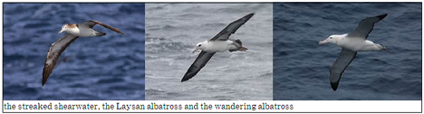
Coming to wind data over the sea, the authors have studied how effective and useful the movement of soaring seabirds can be. Lightweight Global Positioning System (GPS) units were strapped onto the backs of three species, the streaked shearwater (0.6 kg),
the Laysan albatross (3.1 kg), and the wandering albatross (9.7 kg). Their flight path was then plotted by recording their position every second. We can see that this is sixty points for every minute of flight and would provide a fine grained picture of the
flight trajectory. As GPS visualizes the actual movement with respect to the ground, the speed of the wind that is affecting the birds’ flight would be extracted from changes in direction and speed.
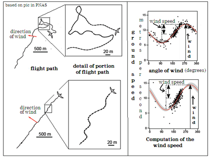
The shearwater and the albatross are suitable because they carry out soaring flight which is largely wind dependent. The estimation of the wind speed is based on the fact that the ground speed is the highest with a tail wind and the least with a head wind,
and in between when the wind is in other directions. The various levels of ground speed, in different directions, over a span of soaring, would thus be distributed in an ‘up and down’ way, as is shown in the picture. And from the shape of the variation of
ground speed in terms of direction, the wind speed and the direction of the wind can be worked out.
The paper details how the wind speeds derived from the bird sensors was verified with reliable instances of data from. The data had been collected at the Funakoshi–Ohshima Island breeding colony in Japan, Ka’ena Point, Oahu Island breeding colony in Hawaii
and at Possession Island, Crozet archipelago in the South Indian Ocean and the areas matched some of the ‘swathes’ covered by the satellite. In the area in the open sea, where the satellite gave good results, there was close agreement with the two sets of
results, the paper says.
While wind data from bird carried sensors could thus supplement that derived from the satellite and buoy mounted sensors, the paper says, and birds could be deployed to collect data in areas where satellite data is not possible, as near the coast. The
attaching of instruments to birds could also be a powerful instrument to study the wind environments that birds encounter during migratory flights, the paper says. Obtaining atmospheric and oceanographic data variables measured by seabird borne sensors is
a unique platform to study conditions far out at sea, “by using seabirds as a fast-moving, living ocean buoy,” the paper says.
[the writer can be contacted at response@simplescience.in]